Day 6 – Reedsport to Langlois, OR

This blue bird hung around, hoping we'd share our breakfast
This morning I woke up before Dallas’s alarm sounded. I had actually fallen asleep and slept fairly well all night! So I guess its not impossible to get a decent sleep in the tent, but I definitely appreciate a good bed. Both of us were in high spirits this morning after having had some good rest, and we enjoyed a leisurely breakfast of apple, cheese, and turkey jerky before packing up the tent and getting on the road.

This is when I discovered that the lighthouse, which we had climbed so steeply to reach the previous night, was not even halfway up the hill. We started our morning off by finishing the ascent before rejoining with highway 101. From there, it was about twenty miles to the next town of North Bend, and another 3 miles to get to Kaffe 101 in Coos Bay, where we remained for a good hour or two. This place was adjoined to a Christian bookstore, and was much larger inside than it appeared from the street. We snagged the table just on the other side of the window where our bikes awaited us and then ordered two cups of soup, a panini, a carrot cake muffin, marionberry scone, chocolate peanut butter cupcake, chocolate covered espresso beans, and two triple-shot lattes. AND we took advantage of their WiFi. So yeah, we were probably there for two hours.

Heavy traffic as we cross the bridge to North Bend
Our goal for the night was a campground by Lake Floras, about 46 miles away. The Pacific Coast Highway is much different from the country roads and forest roads we were on before. This road sees a LOT of traffic – large, heavy, loud, fast-moving traffic. For the most part there is a shoulder or a bike lane to ride on, but the traffic was still far too close for comfort in many spots. In spite of this traffic (or maybe motivated by it) Dallas and I made great time after leaving the cafe…until we reached East Beaver Hill Road. I despise any road with the word “hill” in its name. This was the steepest climb we’ve encountered by far, and it continued for far too long (over a mile…maybe two miles). It was so steep that I tried to stop and walk, but had more trouble pushing my bike up the hill than riding up it.

We saw a bald eagle
We stopped again for groceries in a town called Bandon. It was my turn to go in and buy food, and I came out with half of a roasted chicken. I normally don’t like chicken, but it was strangely appealing to me in the market. We sat on the ground just outside the entrance and ate the warm, delicious chicken before hopping back on our bikes for the last 17 miles or so of rolling hills.

We still had ten miles to go when the sun set
Aside from Beaver Hill, our ride went pretty smoothly and quickly. We had a tail wind and managed to cover 66.66 miles of rolling hills for the day. It was, however, dark when we arrived at the campground, and once again we had to set up the tent in the dark. Hopefully we chose a decent spot!
Day 5 – Out of the forest and onto the coast!

Today was a long day. I have so much trouble finding comfort in the tent, I hardly ever get a good sleep when we camp. Last night was no exception. We had chosen to camp about halfway between Eugene and Reedsport, and in between there were absolutely no services of any kind. Our morning started off with a climb up to the Oxbow Summit. We literally started going uphill about a mile into our ride, and we didn’t have any water or a way to treat or filter water. Dallas kept a slow pace, trying to conserve energy, and for once I spent most of the day leading the way, feeling great for how little sleep I had the night before.

Part of the forest the loggers have been logging
Four and half miles later, we reached a clearcut area of forest where loggers were working. Shortly beyond the logging operation was an RV, and as we pulled up to it a woman stepped out to greet us. After we asked if there would be anywhere to get water up ahead, she offered to give us some water. We are so grateful for this, because we still hadn’t reached the top of Oxbow hill and we weren’t going to see anywhere to get water for another 40 miles. We talked to the woman and her husband for a few minutes – they were watching after the logging equipment while the workers were off duty, and had been in that spot for about 6 weeks already. It’s kind of sad to see them cutting down the trees, but apparently this area that is being logged was burnt in a forest fire in 1966 and is all second growth forest within the last 50 years.

Smith River
We finally reached Oxbow Summit, and from there most of our ride was relatively flat, but we weren’t through the hills just yet. We stopped for lunch, which consisted of an apple with almond butter, cheese, hazelnuts we gleaned from a farm a few days ago, and chocolate. My stomach was grumbling again probably thirty minutes later. Even though we were both starving at mile 25, we agreed to wait until mile 40 before eating the rest of our food, but at mile 38, there was a nice spot to sit off the road, in the sun, and halfway up a pretty steep hill. We finished off our last two packets of tuna salad and the rest of our crackers, and one more baby bel of cheese each. Halfway down the other side of this hill, about a mile after we stopped to eat, there was a little convenience store.

If you're lucky, I'll replace this with the video Dallas took on his phone
We were still in a zone without phone service or internet, but there was an ATM here. We tried to take out $80, but the machine returned $4. It was filled with one dollar bills instead of twenties! Thankfully, the lady at the store apologized for this and replaced the ones with twenties for us. After refueling on water, sugar and caffeine, Dallas was a rocket. I could not keep up with him for the rest of the day. I had been feeling like my legs have gotten much stronger in the last few days, and the rest day really helped. Now I felt deflated and wanted to give up. Dallas stayed with me though, and we made it to the end of Smith River Road where it met up with Pacific Coast Highway 101.

I'm sure thieves would listen to this
Turning south onto this road, we had made it to Reedsport! We made a stop a Safeway to stock up on more food, and by this time it was dark. Dallas had told me about a lighthouse he really liked when he was riding down the coast two years ago, and it just so happens that we were only 5 miles from that lighthouse. Also coincidentally, we ended up getting there exactly two years to the day after Dallas had visited it himself! The Umpqua Lighthouse is pretty awesome. It’s also impossible to photograph so I’ll just have to describe it (but you really have to see it to appreciate how cool it is). We had to climb a nasty hill in the dark to get to it. It’s bright red and white beams of light point downwards to the ocean below, and rotate like a carousel, hitting the trees behind it.

Now we are camping in the same spot that Dallas camped two years ago, and are once again the only hiker/bikers at this campsite. There is a constant howling or whistling of some sort in the background. The wind, maybe? The lighthouse? After a long day of cycling over 62 miles of hilly forest roads, I just hope I sleep better tonight!
Day 4 – Corvallis to Siuslaw Forest

One of the many grassy fields full of sheep (we also rode by cows, horses, llamas, pigs, goats, ponies, chickens...)
Even though I don’t know if it was totally necessary due to stormy weather, Dallas and I were able to take advantage of our time off the bikes on Tuesday. That evening it was so nice, we went for a 4 mile run to get our legs moving (and to compensate for eating a cinnamon roll, donut, and pizza earlier in the day).

A field of pumpkins
The next morning our bodies were feeling refreshed, and we finally had a tail wind! In order to make up for lost time and get to San Francisco as soon as possible, we decided to abandon the Willamette Valley Scenic Bikeway and head to the coast straight from where we were. We made it through 23 miles of flat farmland with the wind at our backs in less than 2 hours. In Harrisburg, we filled our bellies with breakfast food at Jake’s Cafe and split a slice of bumbleberry pie. The next few miles went by quickly as well, then we stopped to stock up on groceries at Safeway in Junction City. It’s god that we stopped, because we didn’t ride by any other food for the rest of the day.

Winding up Wolf Creek Road
Eventually, we turned onto Wolf Creek Road, which led us into the Siuslaw National Forest. Wolf Creek Road also made me wish I had done a few more rides up to the summit of the White Pass when we were living in Skagway. The first two and a half miles of this road basically winded up a mountain. It was only a third the elevation of the White Pass, and I’m sure it wasn’t as steep, but it felt a lot harder with all the weight of our panniers and steel bike frames. We also started riding uphill after already having ridden 50 miles that day. We had been making great time all day, riding 16-17 miles per hour for some stretches. Before we turned onto Wolf Creek Road, I thought we would be able to cover 70 miles easily. Now I was having my doubts.

The forest provides a stark contrast to the farmland we had ridden through to this point
Fortunately, the 4 miles of downhill made up for the treacherous climb, and the next uphill didn’t seem quite as bad. This was probably the most beautiful part of our ride, and I really wanted to stop to take photos but was going too fast downhill. The sun was at the perfect angle to illuminate the tall trees on one side of the road as we descended for the second time. We had covered 64 miles by the time we found a good place to pitch our tent for the night. We have a few more climbs awaiting us tomorrow as we make our way over the coastal mountain range and to the coast.
As we lay in our tent, silence is broken by a strange, loud half-howl. There is movement outside, not far from where we lay. Maybe the spot we chose to sleep tonight is less than ideal? There’s no phone service or wifi for miles around us, so if this post gets published, then we made it out of the forest!

Day 3 – Monmouth to Corvallis, OR

Dallas and I didn’t make it very far today, in spite of our early start. We were on the road by 8am! Neither of us slept very well in the tent the night before. As I was trying to fall asleep, I kept hearing what sounded like fireworks going off sporadically in the distance, with no discernible rhythm. This sound went on for hours. Then, I must have actually slept a little bit because I remember both of us being woken up by the sound of howling in the distance. Maybe coyotes? We were awoken a second time by the howling a bit later, only this time it was MUCH closer. Like, right outside of our tent. Dallas asked me if I had my pepper spray near me. Terrified, we lay there hoping it would go away. That night I dreamt that I had to use my pepper spray – on a hitchhiker.

We were packed up and on the road before daylight really filled the sky. We finally met back up with the scenic bikeway about 7.5 miles into the ride. Here, there was a convenient cafe that offered breakfast sandwiches, quiche, and coffee. I figured we would stop briefly to refuel and then be on our way to Eugene, but once settled in, we ended up staying for about 2 hours! (Dallas’s excuse was that his coffee was still too hot to drink). Here is where our luck seemed to have run out. The weather forecast for the day included lots of rain and possible thunderstorms. We were both tired, and we didnt want to end up stranded somewhere in the middle of farmland, 20 miles from the nearest cover when the storm hit. Since we didn’t sleep well on the ground the night before, we decided to splurge on a cabin rental at the nearest KOA campground. This was just an 8-9 mile bike ride from where we were, and we would be safe from the rain.

Upon arriving at the KOA, we unloaded our bikes and made ourselves home in the cabin. First order of business was showers, then laundry. Food options at the KOA were rather limited, so we ordered a pizza. Then we went for a walk on their “Nature Trail” – a short loop around various trees and blackberry bushes. Back in the cabin, we will rest our legs for the remainder of the evening. It barely sprinkled while we spent our day lounging around the campground, but Dallas assured me that just 30 miles south of us it was probably stormy and miserable. Let’s hope so anyway.
Day 2 – Gervais to Monmouth, OR

A lovely trike with flowers at Graham and Peggy's house - note the apple tree in the background!
This was supposed to be a rainy day, which was going to be quite miserable for riding bicycles. I awoke to the sound of rain outside our window, but the sun hadn’t risen yet so I fell back asleep, thinking about what a wet start we were going to have. When Dallas and I finally did wake up for real, the rain had stopped and blue skies were visible behind the dissipating clouds. The weather forecast had gone from 80% to 0% chance of rain overnight. Dallas and I are seriously the luckiest people ever.

Troy's bike shop in Salem
We got back on the road about an hour earlier than we had started the day before, hopeful to make it about 60 miles. Twenty miles and almost 2 hours later, we were in Salem. We stopped at the bike shop owned by Troy, Graham and Peggy’s son – and we arrived just as the sky darkened and started to spit rain at us. Troy wasn’t there, but the other employees were friendly and said we could leave our bikes inside while we went to get lunch. By the time we had finished eating, the sky was blue again and the sun was shining.

Rainbow!
Our next stop came just 13-14 miles later. Exhausted from the headwind and rolling hills, we took a short detour into the town of Independence to pick up some food at the market. Just a block before the market, we passed a cafe advertising pies and ice-cream. This was just what we needed. The man working there came outside and watched as we were locking our bikes together as if we were crazy. “Nobody ever steals in Independence. They’d get shot. The cops here are good, and everyone knows each other. No one steals.” Still, we weren’t going to risk losing our new bikes! No sooner than stepping inside, the sky opened up for the third time that day and poured rain onto our bikes. The man, who called himself Dutch, asked how he could make our perfect day any better. He explained that the kitchen had closed two hours ago, yet their Open sign was still on and there were three people sitting at a table drinking coffee. He then ignored all of our attempts to say we just wanted dessert while he went on listing the sandwiches and quiches and salads that he could still make for us (it seemed that the only thing out of the question was the soup, which was apparently delicious). Once we could finally get a word in, we managed to order lattes and pie (ice-cream came with the pie at no extra charge!). As we were finishing up our pie, Dutch came over to our table and told the story of the historical town of Independence, which is the end of the Oregon Trail. Then, he seamlessly interluded into a discussion on natural disasters and how the whole west coast from Crescent City to Vancouver is going to be destroyed by earthquakes, volcanoes and tsunamis. Independence is the epicenter of the fault subduction zone, but Dutch isn’t concerned. He’s prepared.

It was after 4pm when we finally said goodbye to Dutch and left his 2EZ Cafe. The sun was shining again, but daylight time was limited. Until just before Independence, we had been following the Willamette Valley Scenic Bikeway, but we decided to take a different route from here and try to cut 7 miles out of the trip. This brings us down the opposite side of the Willamette River and through more farmland. The scenery has been good so far, and the hills and headwinds haven’t been any worse than they were before we deviated from the bikeway. Amongst all the farms and private property, we lucked out again today and found a small spot of state park land with a trailhead. There was a no camping sign, and there was a bar across the entrance to the parking lot, but we were able to slide in with our bikes and find the perfect spot to pitch our tent just as the sun set.
Day 1 – Back in the Saddle Again

Despite two days of false hopes, we were finally, definitely ready to leave on Sunday morning, which happens to be exactly two years to the day that Dallas had initially left Portland before ending up in New Orleans. Still, it was almost noon when we finally rolled away from the house we were staying at in Portland. My loaded bike seemed incredibly heavy, and my legs felt sensitive to even the slightest incline. We were both out of practice after not having toured in so long, so it took a few miles to gain our balance and momentum. That momentum was killed as we followed fallen lifesavers and other pieces of crushed candy up the steep hill to Dallas’s mom’s house in Oregon City.

Riding the Champoeg bike path
After a brief stop in Oregon City, Dallas and I continued to Champoeg (pronounced ‘Shampooey’) State Park – the start of the Willamette Valley Scenic Bikeway, which would take us south to Eugene. At the park, while we shared an apple with almond butter, a park ranger approached and asked if we were camping there. We still had about two hours of daylight, so he pointed us in the direction towards the next campground, about 20 miles down the scenic bikeway.

It seemed like a lot of people were burning things outside today, and the wind kept blowing smoke to our senses before we could see the source of all the fires. We rode through miles of farmland rich with fall crops like apple and hazelnut trees, corn, and pumpkins. We still had just under ten miles to go when the sun touched the horizon.

As we pulled over to put our lights on, a truck pulled over to ask us about our bike tour. Back on the road, just a short distance beyond this and around a corner, the truck was pulled over again. A guy got out as we approached and offered us his parent’s apartment behind their house for us to spend the night. It was half as far away as the campground and included a bed and shower. We eagerly accepted the offer, and they gave us directions to their home.

This is MUCH more luxurious than our tent - thanks, Peggy and Graham!
Graham and Peggy were waiting for us when we pulled up to the garage, where their beautiful apartment is attached. They showed us around and told us to eat or drink whatever we found in the fridge. We are so grateful for such generous people who open their homes up to us, and we both hope to return the favor some day.
Distance covered today was just under 50 miles (not bad for starting at noon).
New (used) bikes for our next adventure
Back in Portland, Dallas and I spent a few days recovering from our travels from Alaska. We needed to get moving though, before the weather turned cold and rainy. It was apparently already too late to miss the rain, so after 2 rest days, we started to get serious about our next move. Dallas purchased an almost new Kona Honkytonk from our friend Alyssa, and I found an excellent deal on a GT Wheels 4 Life Peace tour bike on Craigslist. The former owner of my new steed had just finished riding across the US with it – you can see her blog here: www.missionusa2013.blogspot.com
On Friday, Dallas caught up with family in Oregon City while I ran with our friend Kelly in Forest Park. I spent that weekend testing my bike out on some of John Benenate’s team rides. It’s heavy compared to everyone’s road bikes, but it will definitely get me out of Portland. After spending Saturday and Sunday cycling in the rain, Dallas joined me for Tuesday and Wednesday evening group runs organized by other Skora ambassadors. There’s definitely enough resources to stay active all week in Portland.
My plan was to wait for a few sunny days in a row (which could be weeks here), and get as far south as possible before the rain hits again. We got lucky on Thursday afternoon when the sun came out (and we got to see our friend Kristina, from Sockeye, who had just arrived in Portland the night before).

Hoping to leave Friday, we hurried to get everything we needed together for another long bike tour. Halfway through the day, we decided we wouldn’t be ready and would leave on Saturday instead. Saturday morning came, and we still had a few last minute things to pack and adjust. By Saturday afternoon, we were still not quite ready. Hopefully we haven’t wasted our only two sunny days in Portland. We definitely plan on biking out Sunday morning!
The plan is to head south as far as Eugene together. Then, I may cut west to the coast and ride down the Pacific Coast Highway. Dallas is planning to continue towards Crater Lake (hopefully the National Park will be open again by the time he gets there) and south to visit his dad in Ashland before meeting up with me again in San Francisco. The goal is to get to San Francisco by October 19th. Keep checking back for more frequent updates along the way!
On the Road Again

Dallas and I were able to take advantage of a deal on a rental car to drive from Skagway to Anchorage, from where we found cheap flights to Seattle. Since it’s so hard to get to Alaska, we figured we should explore some more of the state before leaving entirely. We left Skagway on a Wednesday and made stops in Carcross and Whitehorse before heading Northwest on the ALCAN. Once over the White Pass summit and into Canada, we enjoyed clear skies and roads lined with trees of autumn colors, ranging from dark green to bright yellow and orange. The Yukon is SO beautiful, but that first night of camping was FREEZING!

We drove on through places with names like Destruction Bay and Beaver Creek, and then crossed back into Alaska on Thursday afternoon, stopping in Tok and North Pole en route to Fairbanks. We were never far from a picturesque view of mountains, most of which were topped with snow. It actually started snowing on us while passing through Tok. In Fairbanks, Dallas surprised me and splurged on a hotel so we could sleep well in a warm bed. I had offered numerous times to drive, but he insisted on staying behind the wheel.

We took off from Fairbanks relatively early on Friday morning. Both of us had developed an aversion to big cities after living in Skagway all summer, and we were eager to continue on through this one. The day was mainly cloudy, and the enormous mountains surrounding us were mostly invisible. We really wanted to see Denali, but the road is usually only open to personal vehicle for the first 15 miles. A few days ago, they had opened the road up as far as mile 30 (weather dependent). We were fortunate enough to drive twice as far than most tourists who visit during the height of the summer season. Adding to our good fortune, the sun started peaking out in the distance behind the mountains as we neared the 30-mile mark. We paused at this lookout spot to eat some crackers with tuna and avocado, and by the time we were ready to move on the whole sky had transformed to clear blue, and all of the clouds were gone. At every moment on the way up the road, we were both stopping constantly to take photos. On the way down it was even more awe-inspiring.

The sun came out!
The only thing both of us would change next time we visit Denali is our mode of transportation. It was warm and effortless to drive through, but it would have been so much better had we been on bicycles. Throughout our road trip we had to make frequent stops to get out and stretch our legs, run around scenic overlooks, do pushups, yoga, etc. On a bicycle we wouldn’t feel the need to stop to move our bodies, and we could take in all the beautiful scenery without a pane of glass separating us from all of this beauty and fresh air. Another benefit to being on a bike is that we would be permitted to ride the entire 92-mile road through Denali National Park, and not just 15 or 30 miles. The only other option to get that far into the park would be from the seat of a tan-colored school bus filled with other tourists.

Jumping around while out of the car
Continuing south from Denali as the sun disappeared behind the mountains, we saw two moose playing in one of the creeks off the highway. Eventually, we made our way to Talkeetna, a small town best known for being the launching spot for climbers wishing to summit Mt. McKinley. The only place that was open was the Fairview Inn – an historic pub with accommodations on the second floor. The room we were given was filled with nothing but a bed, dresser, and noise from the bar downstairs, but the price was right. Dallas and I each enjoyed a beer from the Denali Brewing Company (located next door to the Fairview Inn) before heading upstairs to our room and falling sound asleep before last call.

Posing in front of the historic Fairview Inn
On Saturday, we walked around Talkeetna, sampling coffee and baked goods from several cafes before heading towards Anchorage. We only stopped briefly in Anchorage to have sushi at Ronnie’s at the recommendation of Alex, a native Alaskan who I had worked with at Columbia in Portland. The rolls were so big, we took enough sushi with us for dinner later that night. Also at Alex’s suggestion, we continued on to Homer, instead of Seward, to where we had originally considered driving. Both towns are at the end of opposite roads on the Kenai Peninsula. Shortly after the sun went down it started drizzling, and we decided to stop and pitch our tent at a campground in Ninilchik. Our luck came through again when we woke up on Sunday morning to clear blue skies.

The drive out to Homer was beautiful, with mountain views on the other side of the bay. It was amazing how green the trees still were down here, while they were all yellow and orange up in Fairbanks and the Yukon. We were able to run 5 or 6 miles along the Homestead Trail after lounging at one of the only cafes still open for the winter season.

Dallas running along the Homestead Trail in Homer
To be honest, the Homestead Trail left for much to be desired. The parking area was across the street and a block away from where we entered the trail. No big deal, once we found the trail. However, we were running up to our eyeballs in a field of fireweed that had turned to cotton, getting white bits of the plant all over our black shirts. Still, not that much of a problem. But the long grass around the trail covered up the surface, which was muddy and full of divots. Not being able to see our footing, I feared that I would twist an ankle or slip in the mud. Our fears grew worse when we accidentally stumbled upon the bottom half of what appeared to be a horse’s front leg. It looked like the leg had been sawn clean off right below the first joint. In addition to all this, the trail was inconsistent and very ambiguous. There were forks, dead ends, clearings (one of which we interrupted a steamy rendezvous between two ATVers), and eventually we had to take a road for quite a distance to get back to the car. None of our issues with Homestead seemed to bother the two big dogs who took joy in chasing us down parts of the trail, romping carefree circles around us through the muck before disappearing amongst the fireweed.
Any chance we got to move around in between long hours of sitting in the car felt great, and the weather could not have been better for us this time. We had to return the car the next morning, so we couldn’t spend the night on the Kenai. As we drove back up to Anchorage, the setting sun lit the sky behind us with shades of pink and orange. It started raining and snowing as we drove North into the darkness.

We totalled over 1600 miles on our Alaskan road trip adventure, yet we still covered less than half of the state. We could have driven more than halfway across the continental US. Another thing I find interesting is that Rhode Island, being the smallest state in the US, has more residents than Alaska. It is such a vast and wild land, empty when it comes to people, but so full of wildlife, mountains, trees, plants, water, and beauty.
The Chilkoot Trail

Dallas and I take a break at the top of the Golden Staircase after summiting the Chilkoot Trail
The weekend before we left Skagway, we hiked the historic Chilkoot Trail. This is a 33 mile long trail that was an established trading route for Tlingit natives, but was famously used by thousands of stampeders during the Klondike Gold Rush in 1898-1900. We were lucky enough to get 3 days of dry weather for our hike – probably the only three days without rain for over a month. June and July had been unseasonably warm and dry for Southeast Alaska, but after the first week of August we had started experiencing the more typical mist, rain, fog and cool weather on a daily basis.

Bear prints in the mud near the beginning of the Chilkoot
The most challenging section of the Chilkoot is a short stretch called the golden staircase, which rises more than 1000 feet in less than half a mile. I was in no way prepared for how rugged the climb would be, and for a few terrifying moments, I thought the weight of my backpack would throw me off balance to my demise. Once over the summit, the Canadian side was beautiful with incredible views of deep blue and turquoise lakes.

Looking out over the Canadian side from the summit
My favorite section was hiking along the gorge between Deep Lake and Lindeman City.

The gorge between Deep Lake and Lindeman City

View from the cabin we stayed in at Lindeman City
On the third day, we made it to Lake Bennett, where the train picks up hikers during the summer season. Since the last train came at the end of August, we had to hike 8 miles along the tracks back to the Klondike Highway, where we tried hitchhiking from Log Cabin. After 20 minutes of waiting at Log Cabin and growing colder in the increasing winds, we started walking towards Fraser, where the Canadian Customs Office is located. Only three cars passed within an hour of walking, including Officer Brown (the strictest of the US Customs officers). The third truck picked us up, but only took us the remaining mile or two to Fraser, where we were able to use a phone and call our friends to pick us up.

Walking the tracks from Lake Bennett to Log Cabin
Last days in Skagway
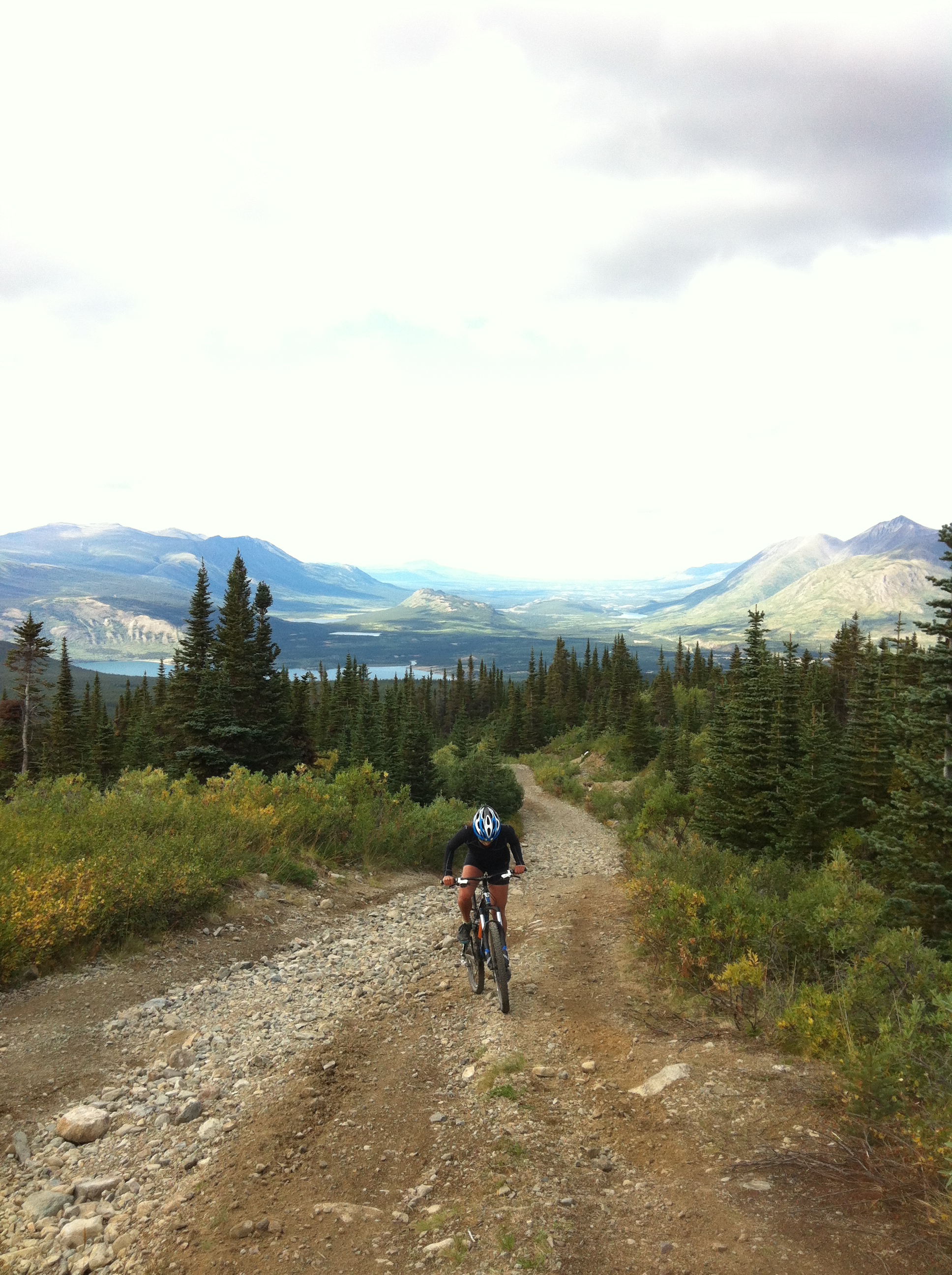
Biking up Montana Mountain in Carcross, YT
Dallas and I decided to extend our stay in Skagway by two weeks, so we could run in the Klondike Road Relay, take advantage of an extra pay period, and of course spend a little more time with the wonderful friends we made while living there. Working as a bike guide could be terrifying at times – trusting cruise ship vacationers to navigate themselves down the White Pass on mountain bikes may be less physically demanding, but is much more stressful than pulling people around in a pedicab. If I work as a bike guide again, I hope the clientele are limited to experienced cyclists who are physically and mentally prepared to do multi-day bicycle touring. Still, this job was a worthwhile and enjoyable experience.
I have never lived with such close access to trails where I could lose myself in nature so easily. Just a 5 minute walk from home could take me to the Dewey Lake trail system, where there are miles of hiking trails. We were also just a 65 mile drive (or bike ride) from Carcross, in the Yukon, where it is always sunny and there are numerous mountain biking trails on Montana Mountain.

Homemade cottonwood oil and salve, bottled just a day after Skagway’s last farmer’s market of the season
From what we were able to forage locally, we made things like dandelion salad, fireweed syrup, blueberry crisp, cranberry-poppy seed muffins, rose water (which I used to make baklava), and cottonwood oil/salve. I only wish I could have finished bottling the cottonwood oil and salve before the last farmer’s market. Cottonwood oil has medicinal properties and can be used as an anti-inflammatory, analgesic, and anti-microbial. As a massage oil, it can be used to ease sore muscles or joints, and it can also be used to heal chapped or scraped skin. If anyone would like to buy one, I will send you a 1oz bottle of oil for $12 or 2oz jar of salve for $15 – just e-mail me or leave a comment on this post.
Looking back at our time in Skagway, both of us are very glad that we decided to spend our summer there. We were able to make great new friends, occupy our free time with a variety of outdoor activities including hiking, running and mountain biking, and we learned so much about the environment and history of the area. Hopefully our friendships will continue far beyond this summer, and we will be able to carry what we learned to whatever awaits us in our next adventure.

The Rockeye Sockeye Robots team at the end of the 24 hours of light mountain bike relay race in Whitehorse

Me, Scott, Ryan, Dillon, Kristin and Zabeth climbed up to Goat Lake on the no-ship day in July
