Category Archives: New Orleans to Newport
Mocoa to Puerto Asís
15 February 2017
It was raining when we were getting ready to leave Mocoa, so we waited a bit for it to let up. On our way out, we came to a public botanical garden, so we left our bikes with the security guard while hiking along a trail through the jungle.
Mochileros, or Gulungos, build these nests that hang from trees like backpacks.
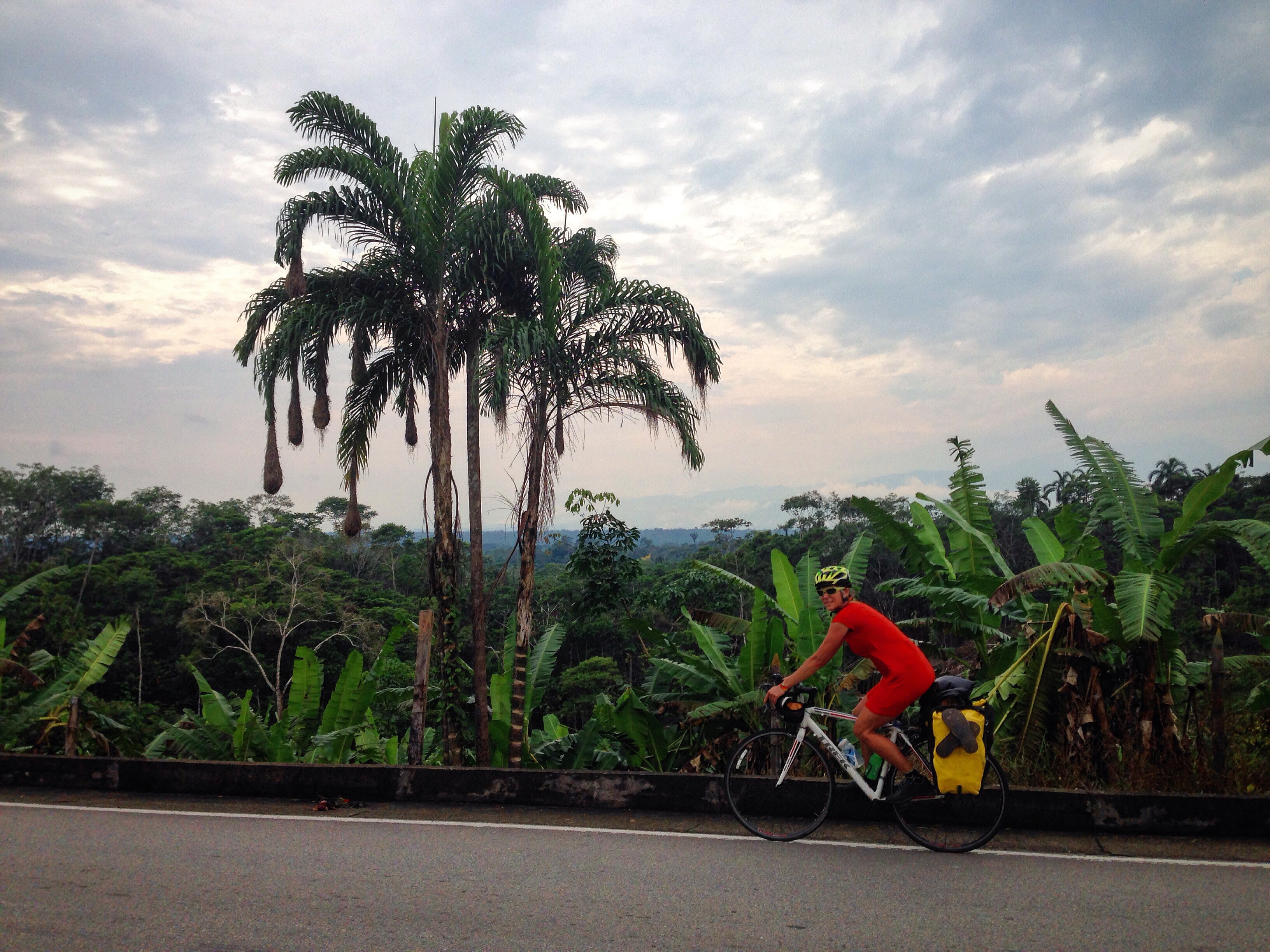
Mocoa is very warm and humid, full of tropical flora and fauna. We saw toucans as well as other birds, known by the locals as mochileros, or backpackers, because the nests that they build look like bags hanging from the trees. We came to a river and decided to let the duckling swim around in a pool of water near the river. I took a few steps towards the water, and suddenly my legs sank into the sand. I was buried up to my knees! I managed to climb out, but I lost one of my flip flops below the sand. Lenin supervised the duck while I dug into the sand in a desperate search for my sandal, mentally preparing myself for the possibility of walking back on the trail barefoot. I eventually gave up and walked to the river to clean my arms, which were now covered in mud. When I walked back to where Lenin was, he had excavated my flip flop as if it were no big deal. It started to rain again on our way back to the road, so we waited with the security guard while it poured outside. Not wanting to be stuck in a room with this guy for too long, we made a break for it when it lightened up enough.
Riding through wet weather on our way out of Mocoa
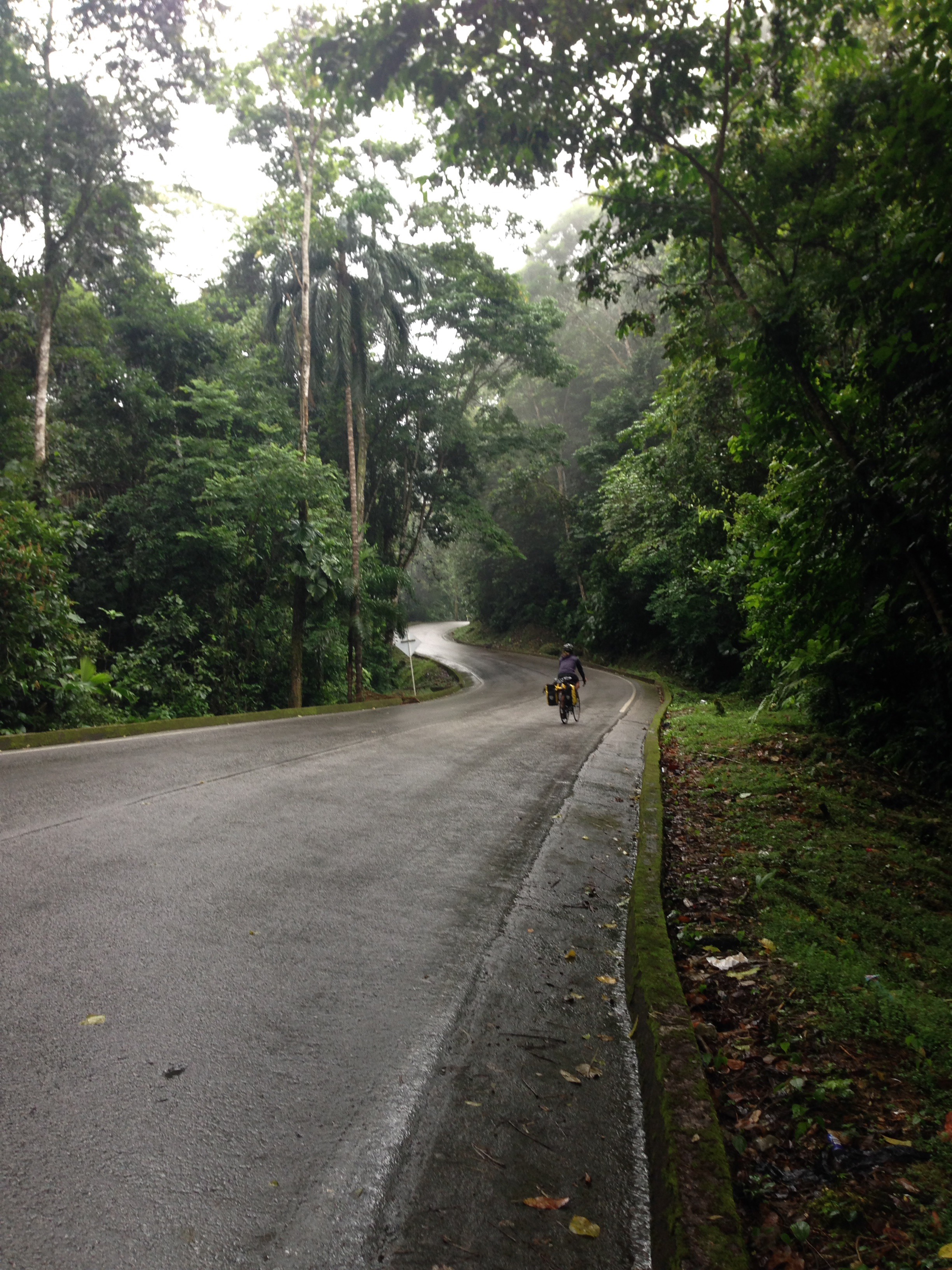
We rode in this drizzle until the Fin Del Mundo, a waterfall that everyone told us we had to see if we go to Mocoa. Near the entrance to the trail for this waterfall, we rolled our bikes into a covered parking area attached to someone’s house and sat talking with the family there while the rain grew heavier. We decided not to go to the waterfall because it was cold, and we didn’t want to pay to see a waterfall when it was too cold and rainy to swim in it.
The rain eventually lightened up again, and we got back on our bikes to leave Mocoa. We stopped in the town of Villa Garzón for lunch and debated whether to just stay in a hotel that night because of all the rain. The hotel was dirt cheap (only $10,000 pesos) because they didn’t have a television, but by the time we finished eating, the rain was gone, and it looked like it wasn’t coming back.
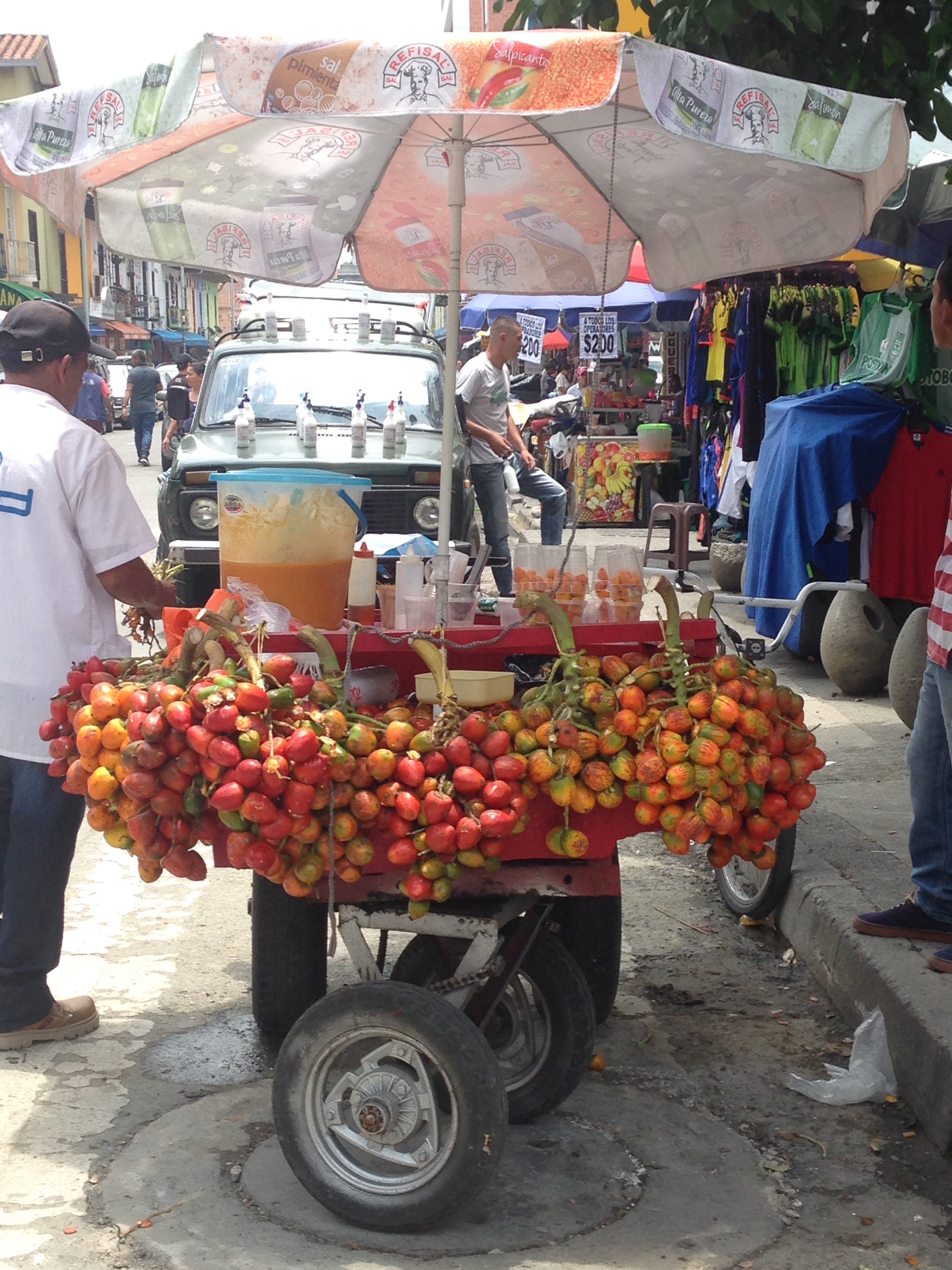
Chontaduros are commonly sold on the streets or of carts, like this one in Medellín.
We made one more stop in San Pedro to snack on chontaduros, a fruit that grows on a tree similar to coconut, but is smaller, orange, and its taste and texture somewhat resembles pumpkin. I first saw this fruit in Neiva, where there are many people selling them in carts on the street. It’s widely available in the warmer climates of Colombia and popular among the black communities. People eat it with salt or honey, and also as a juice with milk or a creamy soup. I definitely preferred it with honey, but my taste is always partial to sweet over salty.
Our ride was mostly flat or downhill, and we remained in a warm, tropical climate the whole way to Puerto Asís. We made it to the town just after sunset, and just before our WarmShowers host, Monica, would be free to meet us in the main square.
Pea Island to Virginia Beach to NYC

Dallas on a sand dune by our camp site
Tuesday was a long day. Dallas and I were hoping to catch the sun rise on the beach that morning, so Dallas had set his alarm for some crazy hour before 6am. I think we missed the sunrise, although I dreamt that we were watching it from our tent. It poured for a few minutes before we emerged from the tent, and then rained again on us while we were packing everything up.
It remained drizzly as we approached Oregon Inlet, and the bridge was long and terrifying, with a small shoulder and large, fast-moving vehicles that passed too close for comfort. We stopped just on the other side of the bridge at a Coast Guard station, where we rinsed sand off of our bikes and refilled on water. The day was going to be a race to stay ahead of the tropical storm that was headed in our direction.

Bodie Island Lighthouse
Just a few miles beyond the Coast Guard station was a public beach with showers, so we stopped there to clean ourselves off. The sky continued to alternate between sun and rain, sometimes both at the same time. Just 3 miles before reaching our first food stop of the day, Dallas got a flat tire. We stopped so he could repair it, and it started to rain on us again. It was almost noon when we finally arrived at the Waverider Coffee and Deli in Nags Head, just 13 miles from where we started early that morning. Dallas’s tire wasn’t staying seated properly on the wheel, so he had to fix that a few times before we could move on.

Wright Brothers National Memorial, with the storm approaching from the southwest
Since diverting our route to leave the island via the Wright Memorial Bridge, we were hoping to catch a ferry in Currituck to Knott’s Island. The last ferry left at 5:45pm and was 48 miles from where we ate lunch. We thought we could make it if we maintained 15 mph, which was definitely possible with the help of the tailwind. The rain ruined that possibility for us when we ducked into another ice-cream shop just before the bridge in order to stay dry. We also took a detour to check out the Wright Brothers National Memorial, on the hill where Orville and Wilbur did most of their test glides and were credited with the first flight in December of 1903. It started raining on us again as soon as we climbed to the top of the hill, but there was an excellent view of the ocean.
The bridge taking us to the mainland was also long and terrifying and littered with debris, but at least there was a wide shoulder. It seemed to take forever to cross this bridge, as we were met with strong headwinds. The traffic did not die down when we made it to the other side, but the road was smooth and the shoulder we were riding on remained wide. It was here when Dallas and I decided to start looking for a ride the rest of the way to Virginia Beach. We still had over 65 miles to go and it was supposed to rain all day on Wednesday. If we didn’t make it to Virginia Beach that night, we would be stuck riding in the storm. There was an overnight bus leaving Virginia Beach every night at 12:30 taking people to New York City. We probably could have made it by midnight if we keep cycling, but it wouldn’t be wise to be on the road for so long after dark, and we would have gone well over 100 miles if we had ridden all the way to Virginia Beach.

Me, Barry and Dallas in front of the first bus company we tried
When we stopped at a gas station between Jarvisburg and Grandy, we were fortunate enough to receive a ride offer from a man who was on his way to Chesapeake. Barry helped us to fit our bikes and panniers in the back of his truck and even dropped us off at the bus “station” where we planned to leave for NYC.
The guy at the bus station said we wouldn’t be able to bring our bikes on the bus, contrary to what the woman told Dallas over the phone when he phoned them to inquire about this. A woman who overheard the conversation informed us of three other bus companies we could choose from, all of which have daily service between VA Beach and NYC. We decided to eat first since we were both starving, and then biked over to the cheapest bus company. This bus was sold out for both their 11pm and 11:59pm departures, so we went to another bus line, which was more expensive but boasted free wifi and electric outlets on board. However, when we got on the bus, they broke the bad news that their bus with the electric outlets and wifi was in the shop and we were going to ride the 7 hours on a regular bus. At least we didn’t have to find a place to sleep that night. Dallas and I arrived in New York City just after 6am on May 30th, where we will likely stay until we find a ride to Rhode Island. The bike tour is over for now while we work and save money over the summer.
Frisco (on Hatteras Island) to Pea Island

Oh, good morning! And happy birthday, Dallas!
The mosquitoes had mostly disappeared by the morning, but we did find a few ticks while packing up our tent. We went back to the cafe we had stopped in the night before, Captain Beaner Bakery, to eat breakfast and publish the blogs that I had written but hadn’t had a chance to upload yet. Dallas and I both found more ticks on ourselves while changing in the bathroom. I finally caught up on my blogging and looked over to see Dallas reading about ticks on his phone. I’m afraid the fear of these insects is consuming his every waking thought.

Dallas and me in front of Cape Hatteras Lighthouse
Despite rising early, we didn’t leave the cafe until after noon. From there, we rode east and checked out the Cape Hatteras Lighthouse. We rode north with the wind for the rest of the day, effortlessly maintaining a pace above 20 mph. Our first stop after the lighthouse was to go swimming on the beach. A Food Lion employee told us we could get free showers at a pool just down the road, so we chose to swim at the beach across from the pool. A group of vacationers hanging out in their own pool offered that we store our bikes under their rental home after watching us struggle to carry them up a few stairs to the first landing of the boardwalk. After our short swim (the ocean was too seaweedy today) we rode over to Club Hatteras, where we swam in the pool for a bit and we able to shower, all for free.
We ate lunch at a deli in the Food Lion plaza, where another man told us what to expect up ahead before we continued on our way north. He recommended a few food and ice-cream places and told us that we would be unable to leave the Outer Banks the way we were hoping to go, straight through False Cape State Park in Virginia. Instead, we would have to get off via the Wright Memorial Bridge in Kitty Hawk. This was good advice, since we wouldn’t have discovered that we couldn’t get through until we had gone more than 20 miles beyond the bridge.

Dallas and Alex on Route 12
Just before reaching the first ice-cream shop that was recommended, we passed another touring cyclist going in the opposite direction. His name is Alex, and we stopped and talked to him for a while. Alex was the first touring cyclist we ran into since leaving New Orleans, and the only one I have ever come across in my travels so far. We exchanged advice for the miles ahead of us before parting ways.

Setting sun behind the Oregon Inlet Bridge
We resumed our fast pace northward until 7pm, when Dallas recommended we start searching for camping spots so we don’t get stuck in the dark. This put us just before the Oregon Inlet bridge to the next island. We were hoping to make it to Nag’s Head that day, but didn’t want to go over the busy bridge while the sun was so low, so we set up camp about a mile before the bridge amongst the large sand dunes, between the road and the ocean. An hour or so after trying to fall asleep, we got up and moved the tent in an attempt to prevent more sand from blowing in and burying us in our sleep.
Ocracoke to Hatteras, NC
The ferry ride to Ocracoke was 2 and a half hours long. I caught up on my blogging while Dallas caught up on sleep. He was probably dreaming about mosquitoes.

On the ferry from Cedar Island to Ocracoke
After arriving on Ocracoke Island, we rode a short distance to Flying Melon Cafe, where we shared a delicious brunch. Right off the ferry there is a small village area that is dense with cafes, restaurants, and ice-cream shops. The best part about beach towns is that there’s no shortage of ice-cream shops. After this strip, there is only one road that goes to the other end of the island, where we catch the free ferry to Hatteras. This road is devoid of any structures at all – no shops, restaurants, houses…nothing. There is a nice bike path that runs as far as the campground, and after that there is a wide shoulder to ride on for another 5 miles or so to the beach. After the beach, there is just a narrow road the rest of the way to the ferry, where there is little else aside from a few vending machines and bathrooms.

Strong waves on the beach in Ocracoke
Dallas and I rode the 14 miles to the other end of Ocracoke at a leisurely pace, enjoying the flat and scenic ride with minimal traffic. There is driving allowed on the beach, so maybe that’s where all the vehicles were. Most of the trucks driving by were carrying coolers and fishing poles, which were blatantly obstructing the view of the road for the drivers.

Seagulls following the ferry to Hatteras
The ferry to Hatteras is free and runs every half hour. It is only a 40 minute ride over shallow waters. Hatteras is a much bigger island than Ocracoke, but the selection of shops and restaurants we were met with upon exiting the ferry was meager in comparison. We rode a few miles to a beach, where we swam and rode the waves for a while and then showered in the public outdoor showers. The tap water around here smells and tastes horrible.
After cleaning up and drying off, we continued up the only road and ate dinner at the only restaurant on the map for miles. We both agreed that it was a terrible restaurant, but we didn’t have a lot of options and we were hungry. Further down the road we came across a cafe that wasn’t on the map, but it was open. The man inside said that they had just bought the place and were in their first week of business, which explains why we couldn’t see it on google maps. He told us we could camp in their back yard if we wanted, which we seriously considered before heading off to the campground nearby.
Upon entering the campground, a park ranger informed us that it costs $20 per night to camp there. She said we could ride around and pick out a site that we liked and then come back to tell her which one we wanted. We rode around the area, which was hilly from sand dunes and had some great views of the ocean, but neither of us wanted to pay $20 to camp out next to a bunch of other campers, including RVs and trucks. After leaving the campground but before reaching the main road, Dallas spotted a small trail leading away from the road. We decided to bring our bikes back there and find a place to camp for free. The mosquitoes were upon us as soon as we decided to take out our tent, so we hurried to set everything up and get inside. The next day (May 28th) is Dallas’s birthday…hopefully the bugs will leave him alone!
Beaufort to Cedar Island, NC

Dallas, Sarah, Irish and me before leaving the house in Beaufort
It was after 11 when Dallas and I finally woke up. We had been hoping to leave by noon and catch the last ferry to Ocracoke Island at 5:30pm, but I needed to get somewhere with wifi to wire money to the realtor of the place we’re going to live in Newport. Noon came and went, and we still hadn’t left Beaufort, so we decided to hang out in the town for a little longer since we were probably going to miss the 5:30 ferry. We’d still leave Beaufort that day but just camp on Cedar Island overnight and catch the first ferry in the morning. There really wasn’t anything else in between Beaufort and Cedar Island, so we figured it was better to spend our time in town rather than get to Cedar Island early and have nothing to do for the rest of the day.

Many of the homes in Beaufort have lawns of wildflowers – much nicer than grass lawns, and less maintenance required!
Our first stop after breakfast was the laundromat, and we walked around Beaufort while our clothes washed and dried. Beaufort is a charming port town, with plenty of ice-cream shops, chocolate, coffee, art, sailboats, and nice homes with large front porches. One of the houses, the Hammock House, was where the pirate Blackbeard lived.
When we were finally ready to leave Beaufort, we made one last stop to split a sandwich and some ice-cream, since we were hungry again. While standing outside with our bikes, a family walked by, and the father, Bill, started talking to us about our trip. He gave Dallas his card before they continued on their way. Not five minutes later, after we had gone in to fill our water bottles, Bill came inside and handed Dallas some money! People never cease to amaze me with their generosity – we are very thankful.
 We finally hit the road at 5:30pm and were met with strong headwinds. For 19 miles we struggled to move forward against the wind before stopping at a gas station to refill on water. We had left rather late, and we were making slow progress. The sun would be down in an hour, and we didn’t want to get caught in the dark without a place to camp. We settled on camping 6 or 7 miles later, under a tall electrical tower, in a town called Stacy. As soon as we stopped we were swarmed by mosquitoes and biting flies. Both Dallas and I slathered ourselves with this natural insect repellent that we had bought from the organic market in Jacksonville, but we were still being bitten. We had to make a decision quickly or else we’d be stuck in the dark, so we set up our tent on the flattest and driest patch of ground we could find. This happened to be over a bunch of broken shells, which were awfully uncomfortable to lie on.
Poor Dallas was really reacting to the mosquito bites. He already had welts all over his legs from the previous days, and now they were attacking him relentlessly. He was reluctant to go back outside to cover his bike once we were safe inside the tent, so when it started to pour, I ran out and covered our bikes. I think Dallas spent a fair amount of time reading about mosquitoes and the diseases they can carry on his iPhone while I tried to fall asleep. It was not a very restful night.
There was some kind of creature nearby our tent that was making the exact same sound as Dallas’s alarm clock, which sounds like a duck quacking. This went on pretty much all night, and when Dallas’s alarm clock finally did go off, I was not ready to wake up. It sounded like it was raining, but then I put my glasses on and realized it was just the buzzing of all the mosquitoes, and the pattering sound came from them bumping around between the tent and the rain fly. We packed everything up before venturing from the tent. In the space between our tent and the rain fly, the mosquitoes were having a party. There were at least 50 of them up there, just waiting for us to come out so they could drink our blood. As we pedaled away from the area, Dallas was sure that the mosquitoes were following him. I did see 3 of them sitting on his right shoulder…

View from the bridge to Cedar Island, over the national wildlife reserve
It was another 14 miles to the Cedar Island Ferry, and Dallas and I rode there nonstop, aside from a pause to take a photo from the bridge over the Cedar Island National Wildlife Refuge. We didn’t make the first ferry, which left at 7am, but we purchased tickets for the next one that left at 10am before going into the motel for a free continental breakfast. We had about an hour to spare before lining up with the motorcycles waiting to get onto the ferry. We had to wait for the long line of cars, including two enormous RV’s (one of which was pulling another car on a hitch) to board the ferry before we were allowed on. I cannot believe all of them fit on such a small boat!
Jacksonville to Beaufort, NC

Me, Eric and Dallas before leaving Jacksonville
Dallas and I departed from Eric’s house and went straight to a diner, where we ate sandwiches and salad, just a mile away. After eating, we rode a few more miles to the organic market to buy snacks for the next few days of riding. It was afternoon when we finally left Jacksonville.
It rained on and off for most of the day, and we kept trying to hide from it under awnings or inside supermarkets or gas stations when possible. About 20 miles into our ride, we crossed a bridge over to Emerald Isle and were able to ride one block over from the main road, avoiding much of the traffic that had been ruining the enjoyment of cycling since leaving Jacksonville. We had forgotten about Memorial Day weekend until we got to Jacksonville and realized that traffic was probably going to be insane.
On Emerald Isle, our course took us parallel to a beach for several miles, and we stopped for about an hour to swim and ride the waves. During this time, the sun came out and stayed bright until we got back on our bikes. Then we were fighting headwinds for the rest of the ride and the sky was threatening us with showers.

Drying off in the sun after swimming on Emerald Isle
Less than 10 miles from Beaufort, we stopped for dinner at a sushi restaurant – probably not the best time to stop, but we were hungry. The sun was gone by the time we had finished eating, and we had to ride the rest of the way to Beaufort in the dark. Fortunately, I had been able to contact Jacqui, a couchsurfer who agreed to host us for the evening, so we didn’t have to worry about finding a place to camp in the dark. Getting over the bridge from Morehead City to Beaufort was scary, since there was only a narrow shoulder, the rail preventing us from falling off the bridge into the water was low, and the winds were so strong it was impossible to hold a steady course on our bikes. We got off and walked over most of the bridge.
Jacqui was an incredibly welcoming hostess. She had warned me over the phone that there would probably not be a couch, but there would be floor space for us, which was more than enough for Dallas and me. When we arrived, there were a few people sitting on the front porch and more people inside. The guy outside introduced himself as Preston and told us that he used to do a lot of bicycle touring himself. He was now in the process of fixing up a sailboat. The couple inside, Sarah and Irish, had been hitchhiking around the US for the past 2 and 4 years, respectively, and decided to settle down for a while in Beaufort after they met Jacqui and her husband, Crunch. Everyone at the house was very cool, and I wish I could have spent more time with all of them. Other people came and went over the course of the night, and Dallas and I did end up getting to sleep on a couch.
Shallotte to Jacksonville, NC
On Thursday, Dallas and I progressed immensely compared to the previous two days. We rose from our camp site around 8 or 9am and left after sharing some Reese’s peanut butter cups and an apple for breakfast. We were on paved roads for no more than 5 or 6 miles before Garmin directed us to turn onto yet another dirt road. Dallas questioned whether we should follow these directions or if we should go 7 miles out of the way and stay on paved roads. He was out of water, so I gave him one of my bottles and figured that we’d be back on paved roads and close to a gas station by the time we ran out of water.

At least there’s no traffic on these roads
An hour later we were still on desolate, unpaved roads, and not a single car had passed us. The only signs of any human activity for 15 miles or so were the tire tracks in the dried mud and a cigarette carton that had been discarded in the middle of the road. We stopped to eat some of our food a few miles before finally reaching a paved road. After a few more miles of riding on pavement, we came to Dale’s convenience store.
We were relieved to find a place where we could fill up our water bottles, and each of us bought 2 cold drinks as well. Sitting at a table in the air-conditioned store, a local man started talking to Dallas about the route we were taking. As we were getting ready to leave, he offered to give us a ride as far as he could in the direction he was going while heading back to work. We gratefully accepted, and he ended up driving us a few miles further than his turn towards work, saving us about 10 miles altogether.

It keeps raining on us!
With 18 miles of riding behind us and an extra 10 miles headway thanks to the ride, reaching Jacksonville that night was beginning to seem realistic. We still needed some real food, so we rode another 20 or 30 miles to the next town, which was Burgaw. There was a laundromat conveniently across the street from the Courthouse Cafe, where we set up shop for a few hours. While waiting for laundry, I got in touch with Eve, a couchsurfer who was out of town for the summer, but graciously gave us her husband’s phone number and said that he could host us.

Sunset in Jacksonville
When we finally left Burgaw, it was after 6pm. Jacksonville was still 35 miles away, and we had 2 hours before sunset. Dallas and I flew for 35 miles down route 53 East, keeping a speed of 18-20 miles per hour and only stopping twice before arriving at Eric and Eve’s home just before dark. Eric greeted us and treated us with great hospitality, offering us food and even cutting a mango for us. A shower and futon to sleep on was a welcome change from camping in the tent, which has become rather sandy and buggy over the past 2 weeks.
Georgetown to Myrtle Beach, SC to Shallotte, NC
 Probably to make up for the long previous day, Dallas and I did not get very far for the next two days. From where we camped, we rode 8 or 9 miles before eating breakfast at Waffle House (not the best choice). We didn’t have to go far on route 17 (aka Ocean Highway) before it started giving off a vacation resort vibe. The road was lined with all sorts of billboards, beachwear shops, fireworks stores and restaurants.
When we reached Garden City, we turned down to the beach, went for a swim and took a nap on the sand. Well…I swam and then read my book while Dallas napped. The water was cool and refreshing after riding under the hot sun. Almost as soon as we left the beach and found a place to eat again, clouds rolled in and it started to rain. When the sky looked safe again, we continued along the road to Myrtle Beach and set up shop again at a Starbucks. I’m amazed (in a disgusted way) by how the seashore is so littered with hotels, and each one advertising their various amenities, such as lazy rivers and swimming pools.

Dallas almost got eaten by a shark in Myrtle Beach
It seems to have been bike week at Myrtle Beach, or maybe they are just preparing for bike week, because everyone had signs outside welcoming the bikers. However, there didn’t seem to be an extraordinary amount of bikers around. The next day (Wednesday) we saw considerably more people out on motorcycles, most of them not wearing helmets.
We stayed at Starbucks for quite a while, reluctant to get back in the saddle. I think the long ride to Georgetown had worn us out a bit. We could not find any couchsurfing hosts to stay with, so we started riding again in search of a suitable place to camp for the night. The place we chose was off the beaten path and along a narrow trail through a heavily wooded area. It was pretty creepy wheeling our bikes through the windy trail in the dark, and I was further frightened when I saw a pair of eyes watching us from a few hundred feet in distance.

Copperhead snake
In the morning I left the tent to pee and almost peed on a snake! It was a copperhead, the snake that people are most likely to be bitten by. The bites are usually not deadly, but are very painful and require immediate medical attention. This was a juvenile snake, which means they are more likely to inject venom when they do bite. I backed away, and we kept an eye on the snake while we packed up the tent.
We found our way out of the wooded area and rode about 6 miles to Cannoli’s Cafe, where we stayed for over 2 hours, eating breakfast and trying to motivate ourselves to move forward. Once we got back on our bikes, we rode on a bike lane that paralleled the beach for several miles before rejoining highway 17. This road brought us finally out of Myrtle Beach and out of South Carolina.

Finally crossing into North Carolina
Shortly after crossing into North Carolina it started raining. We stopped to share an apple on the side of the road and split a vegan raw bar that we had purchased in Charleston. A few minutes down the road again, we came to a creamery and had to stop for ice-cream. It rained again while we sat in rocking chairs on the porch eating our ice-cream. Everyone around here seems to have big porches with rocking chairs outside.
Eventually, we made it to Shallotte, one of the few towns along our route. We usually try to stop whenever we go through a town because places to find food can be hard to find in between towns. We drank coffee and Shallotte and stopped at Walmart to pick up food for the next few meals before heading out of town to find camping.
The sun was going down, so we didn’t get more than 10 or 15 miles out of Shallotte before deciding to turn into a private hunting club’s territory to set up our tent before dark. The dirt road was completely abandoned, and we turned down another dirt road that dead-ended in the forest. There, in the middle of the road just before it ended, was the skeleton of a deer. We set up our tent in the middle of the road several meters before the end, battling mosquitoes as we did so. The ground was hard but flat, and I felt we weren’t likely to run into any copperheads here.
Charleston to Georgetown, SC

Me, Missee and Dallas before leaving Charleston
After spending a day walking around Charleston, Dallas and I spent one more night at Charles and Missee’s house before heading out on Monday morning. Missee made possibly the best grits I had ever tasted, mixed with eggs.

The bridge between Charleston and Mount Pleasant
We didn’t ride very far before stopping for coffee and lunch at the Village Bakery in Mount Pleasant (on the other side of the bridge from Charleston). The 7-layer bar was probably the best thing I’ve tasted in a long time, and I highly recommend it. When traveling, we want to go everywhere and try all the food, but we obviously can’t afford to do so, so we have to be choosy. These are the hardest choices, since we can’t just go back another day and try something else on the menu. That 7-layer bar was one of the best choices I’ve made on this trip. I usually end up liking whatever Dallas ordered better than what I ordered, so it’s a good thing Dallas is okay with sharing everything.
When we got back on our bikes, we rode for a long time before coming to anywhere worth stopping. The only stop we made was to duck out of the rain under the awning of an abandoned convenience store while a storm passed briefly. When we were almost to Georgetown (only 13 miles to go), we took a turn off the main road at the direction of Google maps. Google maps bike directions sometimes will take us out of the way to put us on designated bike trails or to take us off busy roads with dangerous traffic. Unfortunately, it often screws up.

A flower I saw somewhere along the route…
I didn’t notice the chain across the path we turned onto until I had ridden straight into it and had broken the padlock with ease. Oops. We should have turned around and gone back then. Instead, we continued down the overgrown tick and mosquito infested trail that Google maps wanted us to take. Not halfway down this trail (or at least less than half the distance we were supposed to be on this trail), Dallas expressed how horrible it would be if the path just came to a dead end and we couldn’t get through. Shortly after Dallas had voiced his fears, the trail narrowed, went down a steepish hill with even taller grass and ended abruptly in the thick woods. We turned back and rode about a mile towards the road we turned off of before trying out a different trail in the hopes that it might go all the way through so we can continue to follow the purple line on Garmin. This trail was so sandy that it was impossible to maintain control of our bikes, and once stopped, incredibly difficult to start again without sinking into the sand – not to mention the mosquitoes that would flock to us the moment we stopped moving forward. Frustrated (and hungry), we rode all the way back to the main highway 17, losing about 6.5 miles and close to an hour of cycling. We still had 13 miles to go to get to the town.

He’s probably really hungry by now…
Fortunately, there was plenty of daylight left. Still, not many places were open when we arrived in Georgetown, and we were both starving. We ate at Limpin Janes, a restaurant right on the dock. The food was fresh, healthy, not too expensive, and very tasty, and some locals gave us some tips on where we could get a shower that night.
After dinner, we rode a mile or two to a marina, walked our bikes down the dock, and washed ourselves and our clothes in their showers. It was pitch dark when we emerged from the bathrooms. We still had to find a place to sleep that night, so we hopped on our bikes and continued riding north on highway 17. We didn’t want to ride too far in the dark on such a busy road with no real shoulder, so we turned into the first place we found.
The camp site was not ideal, but we had ridden 77 miles that day and were ready to pass out. I didn’t even bring my sleeping bag into the tent. Whatever the place was, we were pretty sure it was private property and we couldn’t tell how visible our tent and bikes would be in the daylight, so we prepared for an early departure.
Beaufort to Charleston, SC

Emerging from our camp site in the afternoon
Dallas and I intended to leave our campsite early, but it was almost noon when I woke up. Dallas is going to have to start being more forceful when trying to wake me up, I guess. I sleep like a rock.
We packed up and made our way back onto the route to Charleston shortly after noon. There was absolutely nowhere to stop until about 23 miles in, where we pulled into a gas station to refill our water bottles, use the restroom and eat lunch. After devouring almost an entire package of Ritz crackers with two small cans of salmon, a bag of peanut m&m’s, an oatmeal raisin cookie and a Snickers ice-cream bar, we got back on our bikes for another 16 miles before stopping for one last snack break at a school.

Tiny frog along one of the trails we rode down
The roads today were diverse. When we weren’t on the busy main road, we were on back roads that were mostly unpaved and ranged from packed dirt to grass to sand to gravel. One road involved crossing under a few gates and passing a No Trespassing sign, and then hopping over another gate on the other end. While the unpaved roads slowed us down a lot, riding on them was superior to riding amongst the fast-moving weekend traffic.
Our warm showers host, Charles, lives on Charlestowne Road in Charleston. He greeted us outside when we arrived and told us to make ourselves at home. After showering, we went downstairs and Charles showed us around the city. We had some tasty Korean food for dinner, and Dallas and I walked from the house to TCBY for frozen yogurt after we returned from our tour.
