Blog Archives
Day 7 – Langlois to Gold Beach, OR

Dallas, listening to Mike at the campground, just as it starts to rain
Today marks the end of a week since when we left, and in total, we’ve gone 350 miles. Both of us woke up bright and early, with high expectations for the day, which we failed to meet. Dallas started tuning his bike derailleurs and tightening spokes, and a man in the campground named Mike struck up conversation with us, delaying our packing. This guy had ridden up and down the coast 13 times before, and also around Australia, New Zealand, and Hawaii. He stuck around for a while, and went on about bicycles, his dogs (at one point he had 12 of them living in his RV with him), and the felony he got after 13 years of selling marijuana in Michigan. We were hoping to get to Port Orford and into a cafe before the predicted rain began, but it started misting just before we were ready to leave. When we did venture out from the safety of the tree cover, it started to rain steadily.

The first 14 miles to Port Orford were pretty miserable, but it actually stopped raining just before we got there. Paradise Cafe is a small diner on Route 101 that boasts free WiFi. We sat down in a booth next to a couple, and the man immediately started talking to us. He told us that they were also camping around there, and they were impressed with our riding. He also told us about their pug (named Pugsly) that only has three teeth and needs to eat special food. Then he must have thought we were bowing our heads in prayer when we were actually trying to steal glances at our menus, because he told us how nice it is to see young people pray before a meal. We politely engaged the couple in conversation, but then moved to a different table after ordering so we could sit by the one outlet we could find and charge our phones. Before leaving, the woman gave us $20 for our breakfast! We are always so blown away by the generosity and kindness of strangers, and this was no exception. It definitely pays to be nice to strangers.

Bridge to Gold Beach
We had perfect weather for the rest of the day, but we were way behind our hopeful schedule, and our legs were just too tired to maintain a fast enough pace. Much of the ride after Port Orford was within view of the ocean, and it really was beautiful riding. We were still 28 miles away from Brookings (our goal) when we stopped in Gold Beach. We found a really cheap motel, although we ended up spending more on dinner at the Port Hole Cafe (we were really hungry!).

Day 5 – Out of the forest and onto the coast!

Today was a long day. I have so much trouble finding comfort in the tent, I hardly ever get a good sleep when we camp. Last night was no exception. We had chosen to camp about halfway between Eugene and Reedsport, and in between there were absolutely no services of any kind. Our morning started off with a climb up to the Oxbow Summit. We literally started going uphill about a mile into our ride, and we didn’t have any water or a way to treat or filter water. Dallas kept a slow pace, trying to conserve energy, and for once I spent most of the day leading the way, feeling great for how little sleep I had the night before.

Part of the forest the loggers have been logging
Four and half miles later, we reached a clearcut area of forest where loggers were working. Shortly beyond the logging operation was an RV, and as we pulled up to it a woman stepped out to greet us. After we asked if there would be anywhere to get water up ahead, she offered to give us some water. We are so grateful for this, because we still hadn’t reached the top of Oxbow hill and we weren’t going to see anywhere to get water for another 40 miles. We talked to the woman and her husband for a few minutes – they were watching after the logging equipment while the workers were off duty, and had been in that spot for about 6 weeks already. It’s kind of sad to see them cutting down the trees, but apparently this area that is being logged was burnt in a forest fire in 1966 and is all second growth forest within the last 50 years.

Smith River
We finally reached Oxbow Summit, and from there most of our ride was relatively flat, but we weren’t through the hills just yet. We stopped for lunch, which consisted of an apple with almond butter, cheese, hazelnuts we gleaned from a farm a few days ago, and chocolate. My stomach was grumbling again probably thirty minutes later. Even though we were both starving at mile 25, we agreed to wait until mile 40 before eating the rest of our food, but at mile 38, there was a nice spot to sit off the road, in the sun, and halfway up a pretty steep hill. We finished off our last two packets of tuna salad and the rest of our crackers, and one more baby bel of cheese each. Halfway down the other side of this hill, about a mile after we stopped to eat, there was a little convenience store.

If you're lucky, I'll replace this with the video Dallas took on his phone
We were still in a zone without phone service or internet, but there was an ATM here. We tried to take out $80, but the machine returned $4. It was filled with one dollar bills instead of twenties! Thankfully, the lady at the store apologized for this and replaced the ones with twenties for us. After refueling on water, sugar and caffeine, Dallas was a rocket. I could not keep up with him for the rest of the day. I had been feeling like my legs have gotten much stronger in the last few days, and the rest day really helped. Now I felt deflated and wanted to give up. Dallas stayed with me though, and we made it to the end of Smith River Road where it met up with Pacific Coast Highway 101.

I'm sure thieves would listen to this
Turning south onto this road, we had made it to Reedsport! We made a stop a Safeway to stock up on more food, and by this time it was dark. Dallas had told me about a lighthouse he really liked when he was riding down the coast two years ago, and it just so happens that we were only 5 miles from that lighthouse. Also coincidentally, we ended up getting there exactly two years to the day after Dallas had visited it himself! The Umpqua Lighthouse is pretty awesome. It’s also impossible to photograph so I’ll just have to describe it (but you really have to see it to appreciate how cool it is). We had to climb a nasty hill in the dark to get to it. It’s bright red and white beams of light point downwards to the ocean below, and rotate like a carousel, hitting the trees behind it.

Now we are camping in the same spot that Dallas camped two years ago, and are once again the only hiker/bikers at this campsite. There is a constant howling or whistling of some sort in the background. The wind, maybe? The lighthouse? After a long day of cycling over 62 miles of hilly forest roads, I just hope I sleep better tonight!
Day 4 – Corvallis to Siuslaw Forest

One of the many grassy fields full of sheep (we also rode by cows, horses, llamas, pigs, goats, ponies, chickens...)
Even though I don’t know if it was totally necessary due to stormy weather, Dallas and I were able to take advantage of our time off the bikes on Tuesday. That evening it was so nice, we went for a 4 mile run to get our legs moving (and to compensate for eating a cinnamon roll, donut, and pizza earlier in the day).

A field of pumpkins
The next morning our bodies were feeling refreshed, and we finally had a tail wind! In order to make up for lost time and get to San Francisco as soon as possible, we decided to abandon the Willamette Valley Scenic Bikeway and head to the coast straight from where we were. We made it through 23 miles of flat farmland with the wind at our backs in less than 2 hours. In Harrisburg, we filled our bellies with breakfast food at Jake’s Cafe and split a slice of bumbleberry pie. The next few miles went by quickly as well, then we stopped to stock up on groceries at Safeway in Junction City. It’s god that we stopped, because we didn’t ride by any other food for the rest of the day.

Winding up Wolf Creek Road
Eventually, we turned onto Wolf Creek Road, which led us into the Siuslaw National Forest. Wolf Creek Road also made me wish I had done a few more rides up to the summit of the White Pass when we were living in Skagway. The first two and a half miles of this road basically winded up a mountain. It was only a third the elevation of the White Pass, and I’m sure it wasn’t as steep, but it felt a lot harder with all the weight of our panniers and steel bike frames. We also started riding uphill after already having ridden 50 miles that day. We had been making great time all day, riding 16-17 miles per hour for some stretches. Before we turned onto Wolf Creek Road, I thought we would be able to cover 70 miles easily. Now I was having my doubts.

The forest provides a stark contrast to the farmland we had ridden through to this point
Fortunately, the 4 miles of downhill made up for the treacherous climb, and the next uphill didn’t seem quite as bad. This was probably the most beautiful part of our ride, and I really wanted to stop to take photos but was going too fast downhill. The sun was at the perfect angle to illuminate the tall trees on one side of the road as we descended for the second time. We had covered 64 miles by the time we found a good place to pitch our tent for the night. We have a few more climbs awaiting us tomorrow as we make our way over the coastal mountain range and to the coast.
As we lay in our tent, silence is broken by a strange, loud half-howl. There is movement outside, not far from where we lay. Maybe the spot we chose to sleep tonight is less than ideal? There’s no phone service or wifi for miles around us, so if this post gets published, then we made it out of the forest!

Arriving in Skagway
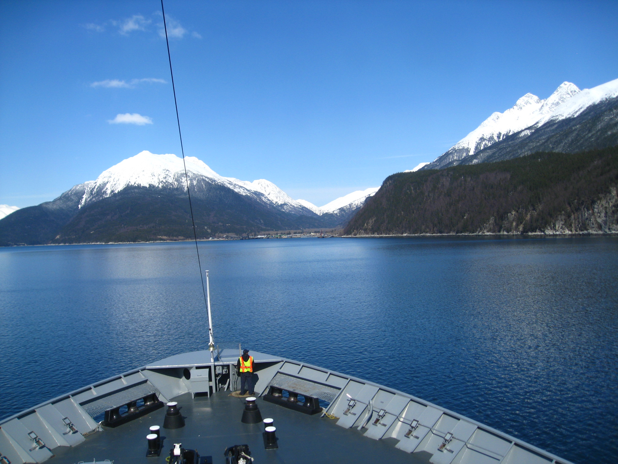
View from the ferry between Juneau and Skagway
We were both so tired, Dallas and I didn’t talk to anyone on the ferry. I was hoping to check out Haines, since the ferry was stopping there for two hours and Christy had told us it was a nice town, but when the ferry docked, I read a road sign pointing 4 miles to Haines. With nothing of interest within walking distance during our short layover, I went back to sleep on the bench next to Dallas. Neither of us were fully awake to appreciate the grandeur view for more than a few minutes before drifting off again, and I didn’t fully wake up until we were a few minutes from landing in Skagway, our destination for the summer.

Scott, Dillon, Kristina, Kellee and Zabeth – some of our fellow guides and housemates for the summer
Dustin and Scott greeted us when we stepped off the boat, and 4 other new guides who had been on the same ferry joined us a few minutes later. We all managed to load our bags into the Sockeye Cycle Van, and Dustin drove our belongings to the house while Scott led the rest of us by foot. It was only a few blocks to the shop, and walking felt good after lounging around on the ferry for 7 hours (three of the other guides had boarded the ferry in Bellingham, and had been on board for 4 days).

View of Smugglers Cove from Yakutania Point
Although it was clear and sunny that day, the announcement of an avalanche having recently blocked the white passage to the Yukon (pretty much the only way out of Skagway by land) reminded us that it was still very much winter in Alaska. Scott, the shop manager who had previously been a mechanic for a tour company in Italy, provided us with numerous and entertaining stories. He had arrived three weeks earlier and told us about his first day and days leading up to now, when it seemed he was finally able to talk to some other people who were seeing Skagway for the first time. I think we all shared his wonder in what we’ve gotten ourselves into here.
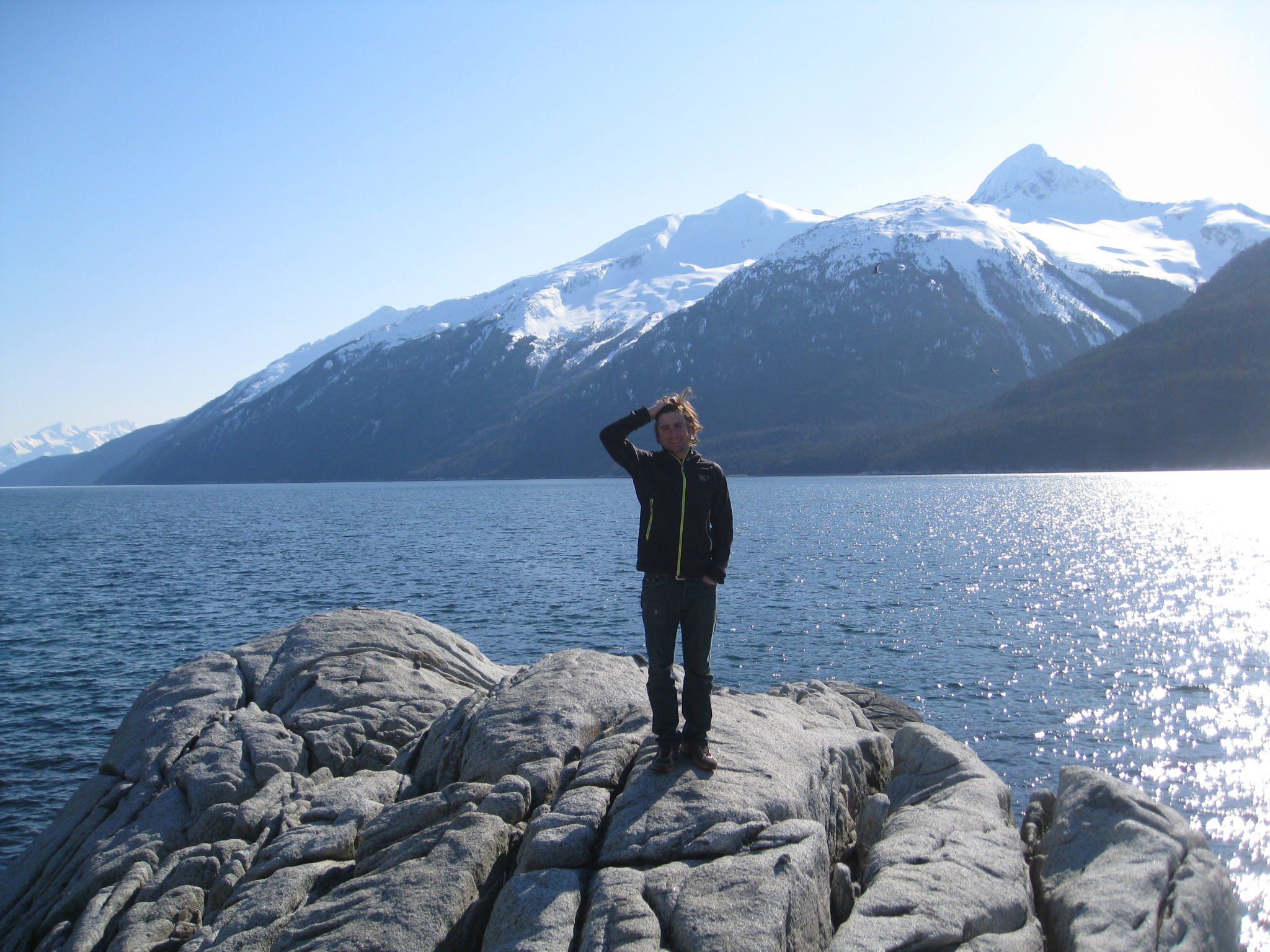
Dallas, standing at Yakutania Point on the day of our arrival in Skagway
The owner of the company, Thom, greeted us when we arrived at our new summer home, the two stories above the Sockeye Cycle bike shop. Then he hurried off to drive to Whitehorse, the nearest city, to buy supplies for the house and our welcome barbecue. Because of the avalanche, he had to take an alternate route to Whitehorse, and it was uncertain if he would even make it back the next day for the barbecue.
Dallas and I will be sharing this space for the next four months with 10 other guides.
